티스토리 뷰
Skill/OpenLayers
[OpenLayers] 마우스 오버시 특정 구역 하이라이팅하기(with ol.interaction.select)
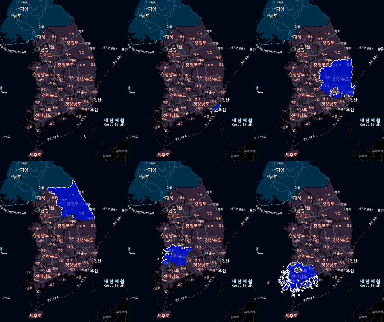
진열사랑 2020. 9. 20. 21:10폴리곤 표출 시 특정지역을 하이라이팅 해야하는 경우가 있는데
이때 ol.interaction.select 객체를 활용하면 간단한 하이라이팅 효과를 줄 수 있습니다.
소스코드
<!DOCTYPE html>
<html lang="">

<head>
    <meta charset="utf-8">
    <title>kithub example</title>
    <meta name="author" content="Your Name">
    <meta name="description" content="Example description">
    <meta name="viewport" content="width=device-width, initial-scale=1.0">
    <link rel="stylesheet" href="https://cdn.jsdelivr.net/gh/openlayers/openlayers.github.io@master/en/v6.2.1/css/ol.css" type="text/css">
    <script src="https://cdn.jsdelivr.net/gh/openlayers/openlayers.github.io@master/en/v6.2.1/build/ol.js"></script>
    <style>
        .map {
            height: 1000px;
            width: 100%;
        }
    </style>
</head>

<body>
    <div id="map" class="map"></div>
    <script type="text/javascript">

            var map = new ol.Map({
                target: 'map',
                layers: [
                    new ol.layer.Tile({
                        source: new ol.source.XYZ({
                            url: 'https://xdworld.vworld.kr/2d/midnight/service/{z}/{x}/{y}.png'
                        })
                    })
                ],
                view: new ol.View({
                    center: ol.proj.fromLonLat([126.978275264, 37.566642192]),
                    zoom: 7
                })
            });

        // 행정구역 데이터 가져오기
        var vectorSource = new ol.source.Vector({
            format: new ol.format.GeoJSON(),
            url: function(extent) {
                var strUrl = 'http://localhost/geoserver/sqlite/wfs?service=' +
                    'WFS' +
                    '&version=2.0.0' +
                    '&request=GetFeature' +
                    '&typename=sqlite:ZONE_SIDO_Co2Intensity_auto_weekday_2016' +
                    '&outputFormat=application/json' +
                    '&srsname=EPSG:3857' +
                    '&bbox=' + extent.join(',') + ',EPSG:3857';
                return strUrl;
            },
            strategy: ol.loadingstrategy.bbox
        });

        var vectorLayer = new ol.layer.Vector({
            style: new ol.style.Style({
                stroke: new ol.style.Stroke({
                    color: 'rgba(0, 0, 0)',
                    width: 2
                }),
                fill: new ol.style.Fill({
                    color: 'rgba(255,0,0,0.2)'
                })
            }),
            source: vectorSource,
            name: 'area'
        });

        //행정구역 레이어 추가
        map.addLayer(vectorLayer);


        // 각 행정구역 마우스 오버시 하이라이팅
        // 마우스 오버시 스타일 지정
        var selectPointerMove = new ol.interaction.Select({
            condition: ol.events.condition.pointerMove,
            style: new ol.style.Style({
                stroke: new ol.style.Stroke({
                    color: 'white',
                    width: 2
                }),
                fill: new ol.style.Fill({
                    color: 'rgba(0,0,255,0.6)'
                })
            })
        });
        // interaction 추가
        map.addInteraction(selectPointerMove);
    </script>
</body></html>
'Skill > OpenLayers' 카테고리의 다른 글
| [OpenLayers] ol.control (0) | 2020.09.22 |
|---|---|
| [OpenLayers] 마우스로 도형 그리기 (0) | 2020.09.20 |
| [OpenLayers] OpenLayers3 와 VWORLD (0) | 2020.09.20 |
| [OpenLayers] 사용법 기초1 (1) | 2020.09.20 |
| [OpenLayers] 개론 (0) | 2020.09.20 |
댓글
공지사항
최근에 올라온 글
최근에 달린 댓글
- Total
- Today
- Yesterday
링크
TAG
- border-collapse
- spring
- devtools
- getter
- 정규식
- oracle
- CSS
- object key
- excel
- caniuse
- JQuery
- Keycode
- sumifs
- 진열사랑
- lombok
- draw.io
- QueryDSL
- Javascript
- @ExceptionHandler
- DatePicker
- $.extend
- $.each
- ul li로 테이블
- setter
- springboot
- 여러 컬럼 update
- element위치
- PostgreSQL
- 프로젝트명변경
- 전후방탐색
| 일 | 월 | 화 | 수 | 목 | 금 | 토 |
|---|---|---|---|---|---|---|
| 1 | 2 | 3 | 4 | 5 | 6 | 7 |
| 8 | 9 | 10 | 11 | 12 | 13 | 14 |
| 15 | 16 | 17 | 18 | 19 | 20 | 21 |
| 22 | 23 | 24 | 25 | 26 | 27 | 28 |
글 보관함
